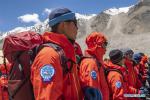
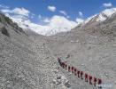
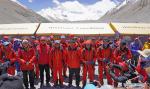
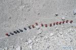
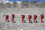
MOUNT QOMOLANGMA BASE CAMP, May 8,2020 -- A team of over 30 Chinese surveyors Wednesday left a base camp at Mount Qomolangma for a higher spot on their journey to the peak, as they endeavour to accomplish a mission to remeasure the height of the world's highest mountain.
The team, consisting of professional climbers and surveyors from the Ministry of Natural Resources (MNR), will seize the current weather window and attempt for the summit at the optimal time.
The surveyors will conduct surveys at the summit using devices including the Global Navigation Satellite System and gravimeter, said Wang Yongfeng, vice director of the mountaineering administrative center of the General Administration of Sport.
The surveyors arrived at the base camp at an altitude of 5,200 meters, located in Tingri County of Tibet Autonomous Region in southwest China, early April for training on mountain climbing and surveying skills in the high-altitude region, said Wang.
"We are very excited and also very confident about the mission. We will do our utmost to ensure its success," said Wang Wei, one of the surveyors.
The core of the mission is to accurately measure the height of Mount Qomolangma, which can be used for research in fields such as geodynamics. Accurate data on snow depth, meteorology and wind speed at the summit will provide first-hand material for studies related to glacier monitoring and ecological environment protection.
Located at the China-Nepal border, Mount Qomolangma is the world's highest peak, with its north part located in Xigaze prefecture of Tibet Autonomous Region.
Since the founding of the People's Republic of China in 1949, Chinese surveyors have conducted six rounds of scaled measurement and scientific research on Mount Qomolangma and released the height of the peak twice in 1975 and 2005, which was 8,848.13 meters and 8,844.43 meters respectively.
In 1975, when the Chinese mountaineering team scaled Mount Qomolangma, no professional surveyors reached the top. But the mountaineers took a survey marker to the summit, which helped surveyors from nine observation stations near the mountain to calculate that it stood 8,848.13 meters tall.
"The survey marker must be taken to the summit by man," said Zhang Qingtao, vice captain of a surveying team of the MNR, adding that it serves as a target for observers at the foot of the mountain to aim more accurately at the very pinnacle of the summit.
Today, with the development of surveying technology and methodology, professional surveyors can better perform the complicated work at the summit, said Li Guopeng, captain of the surveying team.
"Professional surveyors are more adept at using the advanced devices. Therefore, the data they obtain are more reliable, scientific and convincing," said Li.
He added that surveyors can also help limit the amount of time spent at the summit, which will reduce mountaineers' exposure to the low-temperature and anoxic environment.
Due to the unstable airflow as well as the windy and low-temperature conditions, surveying-oriented drones cannot work at the summit of Mount Qomolangma at present, said Li, adding that "this may be a trend in the future."